


SALE COMMUNITY WEB |
The online guide to the Sale and Altrincham Community, its social and business activities for residents and visitors |
|---|---|
| HOME | ABOUT | SOCIAL | COMMUNITY | INFORMATION | BUSINESS | MISCELLANEOUS | CONTACT |
|
|
|
|
History(The following taken from 'A History of Sale from earliest times to the present day' N.V. Swain Sigma press 1987 and from 'Looking Back at Sale' Vivien Hainsworth, Willow Publishing 1983. Photographs of old Sale by permission of Sale Local Studies Centre at Sale Library). BeginningsSale is situated in the Mersey Valley and this area was used as a route to the Pennines from prehistoric times. The whole of Sale lies less than 30m (100ft) above sea level just on the edge of the valley. Prehistoric man first came to the area more than 6000 years ago. They preferred to live on high ground in hill forts and the only prehistoric find so far in Sale is a flint arrow head discovered in the garden in Holly Bank (off Derbyshire Rd) in 1894. The Romans, famous for their roads, built one on the line of what is now the A56. It branched off Watling St and connected the forts at Chester, Northwich and Manchester. The modern road leaves the line of the Roman one near West Timperley, passes through Altrincham and rejoins the original route. In 1938 some blocks of sandstone measuring 1.2m x 305mm (4' x 1') were unearthed near Timperley Brook and could be the remains of the Roman ford over the brook. The social fabric of the Romans was swept away by the arrival of the Anglo Saxons in the 5th century AD. These colonists consisted of Angles, Saxons and Jutes from the Baltic areas of Schleswig and Jutland. Some Frisians and Franks also made up the numbers of these newcomers. What is now Cheshire was colonised by Angles by the 7th century. These people were several generations removed from the original invaders. Cheshire (Chester shire) was formed as a shire of Mercia in about 900 AD. There was some Norse occupation around the Wirral and Danish settlement in east Cheshire. There is a deed referring to a grant of land in "the township of Sale" in the 12th century. Because it is referred to as a township rather than a manor, the inference is that there was a settlement in Sale during the Anglo Saxon period since townships were their creation. These townships although part of a feudal system were more democratic than the Norman manors that supplanted them. You may wonder why the township of Sale still existed in the 12th century when the Normans arrived in 1066 and one would think that Sale would have become a Manor. There were a number of rebellions against the Normans especially in Mercia and around 1069-70 Cheshire was laid waste by William the Conqueror's army. The shire then became a principal base in the wars with the Welsh and emphasis was placed on military strength rather than economic development. Sale and Ashton are not mentioned in Domesday Book but neither are many other known places. The name 'Sale' is thought to be derived from the Anglo Saxon sealh, a willow, meaning 'the place where the willows grew'. More evidence also derives from field names. A useful source is the Sale Moor Enclosure Act of 1805. The following year a map was drawn of the whole of Sale with an accompanying schedule, allowing us to see the location of every field in the township. Details of each field's size, shape and name were also given plus whether it was enclosed and the owner's name. From this we gain evidence of what Sale was like in the Middle Ages when the Anglo Saxon names were still in use. Dane Rd is probably the oldest road in Sale (apart from the Roman A56). Dane is derived from Anglo Saxon denu, dene, daenland - a valley. Another road with Anglo Saxon origins is Fairy Lane. It is almost a continuance of Dane Rd and is derived from A.S faer - road, way. Other field names such as Street Field (straet), Hurst (hyrst - a wood), Farry Yort (feorr - far, eort - earth or ground) are all Anglo Saxon. Medieval farming in Sale appears to have been a balance between cattle and arable. Sale could be seen as divided into four areas: In the 17th century the area lying south of Marsland Rd as far as Baguley Brook was cultivated in fields of between 1 and 12 acres enclosed by hedges. The hedges were planted before the digging of the Bridgewater Canal in the 18th century and the resulting enclosures were the result of an agreement between farmers and nothing to do with the 1805 Act of Enclosure. Before the 17th century enclosures Sale Moor extended along the entire length of Washway Rd from the Timperley boundary to School Rd. There was then a road along the Northenden boundary along which cattle from the heys on the moor were driven to markets in Altrincham and Stockport. The crops grown in the Middle Ages were mostly peas and beans, barley for bread and beer and hay for the cattle in winter. Sale and Ashton and other places along the Mersey Valley had plentiful lush meadows or 'ees' as they were called in Anglo Saxon. Fish would be part of the diet as well. The beef reared in those times was not consumed by the ordinary people. The names for the flesh beef, mutton, pork, venison, pullet are Norman-French. The only Anglo Saxon flesh name to remain was 'bacon' which the ordinary folk did eat. They also had the entrails, known as 'umble', hence the term 'umble pie'. From the translation of the Latin land deed mentioned earlier it appears that the northern boundary of pre Conquest Sale lay about one third of a mile further north of the present course of the Mersey. By the seventeenth century Sale had become a farming and weaving community. There was a thriving cottage industry making 'garthweb', the woven material from which horses' saddle girths were made. The flax and hemp required were both grown locally. In 1765 the Industrial Revolution made its impact in the form of the Duke of Bridgewater's Canal. This provided a means of transportation of goods and people.Back to top Land holdingUnder William the Conqueror the Anglo Saxon shires became counties, each administered by a count, although later the Anglo Saxon title of earl re-asserted itself. Half of the manor of Sale was held by Thomas de Sale from William FitzNigel probably in the second half of the 12th century. The other half of the manor was held from William FitzNigel by Adam de Carrington, then Adam de Dutton from Carrington and finally by Richard Massey in 1187. Richard was a member of the Masseys, Barons of Dunham.Thomas de Sale had no male heir so his half passed to John Holt who married Thomas' daughter, Ellen. By the 17th century both the Holts and the Masseys had sold land to various people including, in the case of Holt's descendent Thomas to Sir George Booth of Dunham Massey in 1604. The Booths later became the Earls of Stamford. Sale Old Hall The Old Hall, on the south side of Rifle Rd, that was demolished in 1920 was the final building in a sequence probably dating back to the Middle Ages. In 1840 Mrs Mary Worthington rebuilt the hall which was then 200 years old. The Old Hall, on the south side of Rifle Rd, that was demolished in 1920 was the final building in a sequence probably dating back to the Middle Ages. In 1840 Mrs Mary Worthington rebuilt the hall which was then 200 years old. The datestone of the 1920 building was removed and fixed to the lodge inside Worthington Park. It's inscription shows two dates JM1600 and MW1840, the former denoting James Massey. James, son of Richard, only succeeded to the estate on the death of his father in 1603 so the dates do not quite match if they denote building date. However, the hall was probably built around that date as the 1801 estate map shows a typical E shaped Jacobean building. This hall would have most likely replaced an earlier, timbered building, which may or may not have been on the same site. There is a surviving medieval hall at Baguley, a neighbouring manor. Baguley Hall was built in the 14th century and is an important example of medieval timber framed buildings. When James Massey died in 1649 the estate passed to his oldest son, Richard. Richard later (1684) settled the hall and demesne lands on his daughter, Katherine, who married Robert Malyn. Richard's younger brother, William, married Ursula Domville and he built a house in 1688 in Fairy Lane known as Sale New Hall. This was demolished in 1953. Robert and Katherine's son, Massey Malyn, was rector of the parish from 1717 to his death in 1729. The male line of the Masseys died out before the end of the 17th century. The principal later landowners of the Massey estate were the Earl of Stamford and Warrington, the Leghs and Egertons and Charles White. NOTE: If you go to Old Maps and search on grid reference 380762,392321 you will see an 1882 map of the area showing the Old Hall. You can even see a modern map of same area by clicking on link at bottom of screen. Nifty!! Ashton on MerseyThe land tenure in Ashton is rather obscure. In the 14th century it would seem that half the lands were held by the Boydells of Doddleston and the other half by the Asheton family, probably from the barons of Dunham. Eventually most of the manor belonged to the Breretons of Handforth, who sold the estate to Sir Joshua Allen (later Viscount Allen of Stillorgan, Ireland). RoadsCross St 1900
When Sale was first founded what is now Cross St and Washway Rd already existed as part of the Roman road from Chester to Manchester. Nearly as old, with pre-Conquest origins, is Dane Rd, part of Old Hal Rd, Wythenshawe Rd and Fairy Lane. As the earliest cultivated land in the area was the Mersey Valley, roads had to give access to it and Cow Lane is one example. Leading from Arnesby Ave, it slopes down from the steep edge of the valley. The name Brooklands came about as a result of Brooks selling land to the railway company on the understanding that the station was named Brooklands which gave rise to the surrounding area becoming known as Brooklands. Strictly speaking people here live either in Sale or Baguley depending on which side of the Brook they live on. EnclosureIn 1805 an Act of Parliament was passed to enclose 'a certain common called Sale Moor, and other Waste Lands, containing in the Whole One Hundred and fify-two acres'. Enclosure was a nationwide process which was gradually changing the english landscape of open fields farmed by all the villagers, into separate fields bounded by hedges or walls. In the open system the large fields were divided into strips allocated to the villagers and the Lord of the Manor. The strips were divided from each other by open drains and plough furrows. The surrounding lands and woods were also shared communally. For several centuries there had been controversy involving these common lands. By the nineteenth century many peope were losing their rights to cut turf, gather fuel and graze animals. Even if someone successfully claimed ownership, the cost of hedging it was so great they would have to sell it, resulting in loss of livelihood and foodstuff. Many such people were forced to apply for charity to the Parish or to migrate to the towns to seek employment there. Sale Township minutes start to mention poor relief measures for the first time. Schools and Churches
In the days of the Trust School Lane, later School Rd, took its name from the Township School at the top of the road. It was built in 1800 to replace two cottages used as a school in Springfield Rd. The Township school was situated about half way between the National Westminster bank and Boots the chemist. It catered for about 150 children and housed the schoolmaster. A rather lurid tale involves an association between the school and Charlie Peace, a cat burglar, hanged in 1879 for killing a policeman who tried to apprehend him in the act of burglary. An old pupil writing in the 1920s recalled Charlie giving violin lessons or a lantern slide show in the school. The Bridgewater CanalImprovements in methods of transportation were the major factors in the development of Sale. The Sale section of the Bridgewater Canal was finished in 1765. It promoted trade in fresh market garden produce from north Cheshire to Manchester's markets. It was originally constructed to move the Duke's coal from his mines in Worsley to Salford, Manchester and then Hollin Ferry, the Mersey river and Liverpool. In the 1870s there were about 400 horses working on the canal enabling Sale residents to take the 'swift packet' to work in Manchester. The boat the 'Duchess Countess' travelled between Warrington and Manchester for over 80 years until the 1920s when it was finally discontinued. RailwaysIn 1849 the Manchester South Junction and Altrincham Railway was opened. Sale was now a pleasant suburb of Manchester, which was growing increasingly wealthy on the back of cotton. The growth of both areas became inter-related. Sale was suddenly a pleasant place for the rising middle class of merchants to build their homes. They were away from the pressures of the city but within easy reach. Communication links played an important part in the growth of the suburbs. The railway was a major factor in the growth of Sale. The population of Sale more than tripled by the end of the nineteenth century. Famous Salians
James Joule (1818-1889) the famous scientist who researched energy (and the reason energy is measured in Joules and Kilojoules- KJ).
|
INFORMATION |
COMMUNITY |
SOCIAL |
OTHER |
||
|
Council Services Trafford
|
Leisure |
 |
|||
 |
|||||
 |
 |
||||
 |
 |
||||
Copywrite Sale Community Web 2022 |

 The Crossford bridge, carrying what is now the A56 over the Mersey, was present as early as 1538 as it is described in that year by the antiquary, John Leland. Interestingly it must have suffered some damage or other since it is not on the maps in 1577. There is mention of it being 'reedifyed' (rebuilt) in 1578. The bridge was probably the one broken on government orders in 1745 to delay the advance of the Jacobites.
 Before 1902 schools were not paid for out of public funds (rates). Education was provided by voluntary schools associated with various churches and a body of Trustees. In 1902 Sale was called upon to form a School Board.
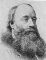
 Samuele de Gaunt (1926-1979) the well-known Portugese folk guitarist and activist) who spent the years 1968-1974 in Sale.For a fuller list check out the